Modern engineering projects demand greater accuracy, faster delivery, and improved collaboration than ever before. As construction, infrastructure, and industrial developments become increasingly complex, traditional surveying methods often struggle to provide the speed and precision required for efficient project execution. This is where 3D Laser Scanning has become a game-changing technology across the engineering sector.
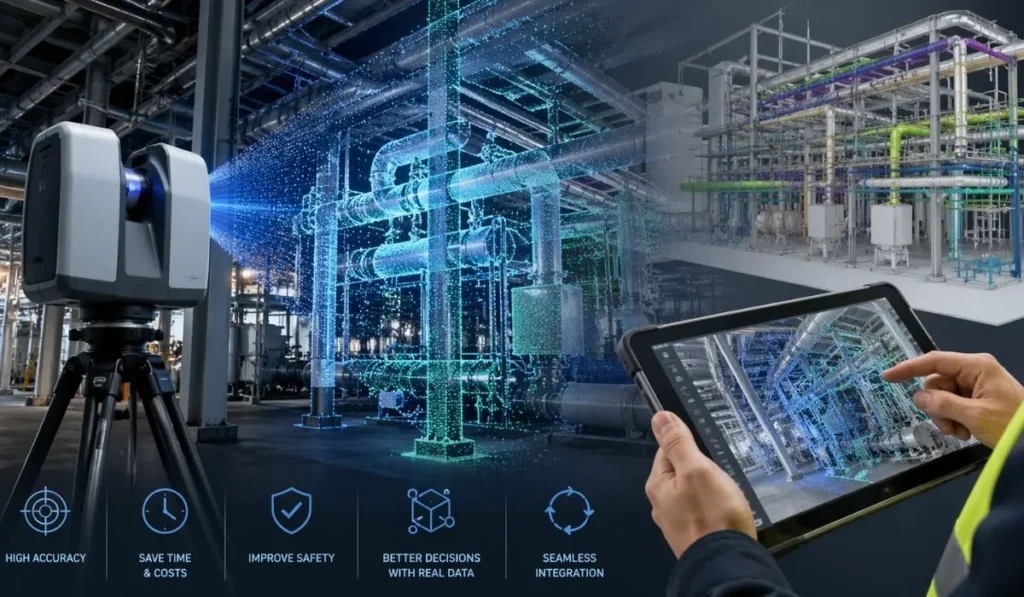
By capturing millions of highly accurate data points in a short period of time, 3D laser scanning creates detailed digital representations of buildings, structures, and environments. These point cloud models help engineers, architects, and contractors make informed decisions while reducing errors, delays, and costly rework. In addition, the technology improves safety by allowing surveys to be completed with minimal disruption and reduced physical access to hazardous areas.
Today, engineering firms are integrating laser scanning into Building Information Modelling (BIM), digital twin creation, clash detection, and asset management workflows. As a result, projects can move from planning to construction with greater confidence and efficiency. Whether for infrastructure upgrades, industrial retrofits, or complex construction developments, 3D Laser Scanning is now an essential tool for delivering accurate, data-driven engineering solutions.
What Is 3D Laser Scanning?
3D Laser Scanning is an advanced surveying technology used to capture the exact shape, size, and spatial details of physical environments with exceptional accuracy. Using laser beams and LiDAR technology, scanners rapidly collect millions of measurement points from structures, equipment, buildings, and landscapes. These captured points are then combined to create a highly detailed digital representation known as a point cloud.
Unlike traditional surveying methods, which often require manual measurements and extended site time, laser scanning delivers fast and non-intrusive data capture. As a result, engineering teams can survey complex or operational environments safely and efficiently while minimising disruption to ongoing activities. This makes the technology especially valuable for industrial facilities, infrastructure projects, construction sites, and refurbishment works.
Once processed, the point cloud data can be converted into accurate 3D models and integrated directly into BIM workflows, CAD platforms, and digital engineering systems. Consequently, project stakeholders gain access to reliable site information that supports design validation, clash detection, planning, and asset management. Because of its speed, precision, and versatility, 3D Laser Scanning has become a critical part of modern engineering and construction processes.
How 3D Laser Scanning Works
The process of 3D Laser Scanning begins with capturing detailed measurements of a physical environment using specialised laser scanning equipment. These scanners emit laser beams that bounce off surrounding surfaces and return precise distance measurements within seconds. As the scanner rotates, it records millions of data points from multiple angles, creating a complete digital snapshot of the site.
Site Data Capture
During the scanning phase, engineers position the scanner at various locations around the project area to ensure full coverage. Because the technology captures extensive spatial information quickly, even large or highly complex environments can be surveyed efficiently. In addition, scanning can often take place while facilities remain operational, reducing downtime and disruption.
Point Cloud Generation
Once the site data is collected, all scan positions are stitched together using specialised software. This combined dataset forms a detailed point cloud containing accurate coordinates for every captured surface. The point cloud acts as a digital replica of the real-world environment and can be viewed, measured, and analysed with exceptional precision.
Processing and Modelling
After processing, the point cloud data can be transformed into intelligent 3D models, engineering drawings, or BIM-ready assets. These outputs support a wide range of project activities, including design validation, clash detection, retrofit planning, and construction coordination. As a result, project teams gain access to reliable information that improves decision-making throughout the project lifecycle.
Integration with BIM and Digital Engineering
One of the biggest advantages of modern laser scanning technology is its seamless integration with Building Information Modelling and digital engineering workflows. By combining accurate scan data with BIM platforms, engineers can improve collaboration, reduce errors, and create more efficient project delivery strategies. Consequently, organisations can achieve better project outcomes while saving time and costs.
Why Modern Engineering Projects Depend on 3D Laser Scanning
Engineering and construction projects are becoming more complex, data-driven, and time-sensitive. As a result, project teams require highly accurate site information to minimise risk, improve coordination, and maintain efficient delivery schedules. This is why 3D Laser Scanning has become an essential technology across modern engineering sectors.
Improved Accuracy and Precision
One of the primary advantages of laser scanning is its ability to capture highly detailed measurements with exceptional precision. Traditional surveying methods often rely on manual measurements, which can lead to inconsistencies and missing data. In contrast, laser scanning collects millions of accurate data points in a matter of minutes, creating a complete digital representation of the environment.
This level of accuracy is particularly important for retrofit projects, industrial facilities, and infrastructure developments where even small measurement errors can lead to costly rework. By using reliable point cloud data, engineers can confidently design and coordinate projects with reduced risk of clashes or inaccuracies.
Faster Project Delivery
Speed is another major reason why engineering firms increasingly rely on this technology. Because site data can be collected rapidly, project teams spend less time on-site and more time progressing with design, modelling, and planning activities. In addition, digital workflows allow information to be shared quickly between stakeholders, helping projects move forward more efficiently.
Furthermore, faster surveying and modelling processes reduce delays caused by missing information or repeated site visits. This ultimately improves project timelines and supports more predictable delivery schedules.
Enhanced Safety on Site
Many engineering environments involve hazardous areas, confined spaces, or operational equipment that can be difficult and dangerous to access manually. Fortunately, 3D Laser Scanning allows data to be captured safely from a distance without requiring direct physical contact with structures or machinery.
Consequently, organisations can reduce risks to personnel while still obtaining highly detailed survey information. This safer approach is especially valuable in industrial plants, infrastructure inspections, and active construction environments.
Better Collaboration and Coordination
Modern projects involve multiple disciplines working together across digital platforms. Accurate scan data improves communication between engineers, architects, contractors, and project managers by providing a shared visual representation of the site.
When integrated into BIM workflows, laser scan data supports clash detection, design validation, and construction planning. As a result, teams can identify issues earlier, improve coordination, and avoid costly modifications during later project stages.
Reduced Costs and Rework
Rework remains one of the biggest challenges in construction and engineering projects. Incorrect measurements, outdated drawings, and incomplete site data can significantly increase project costs. However, by using accurate digital surveys from the start, project teams can reduce errors and make better-informed decisions throughout the project lifecycle.
Over time, this improved accuracy helps reduce material waste, minimise delays, and optimise resource allocation. Therefore, organisations that adopt 3D Laser Scanning often achieve greater cost efficiency and operational performance.
Key Applications of 3D Laser Scanning in Engineering
As digital engineering continues to evolve, 3D Laser Scanning is now widely used across multiple industries and project types. Its ability to capture highly accurate spatial data makes it valuable for planning, construction, maintenance, and asset management. From infrastructure developments to industrial facilities, the technology supports smarter and more efficient project execution.
Building Information Modelling (BIM)
One of the most important applications of laser scanning is its integration with Building Information Modelling workflows. Scan data can be converted into highly detailed BIM models that accurately represent existing site conditions. This helps engineers and designers create coordinated models with fewer errors and improved design accuracy.
In addition, BIM integration supports clash detection, construction sequencing, and facility management. As a result, project stakeholders can collaborate more effectively using reliable digital information throughout the project lifecycle.
Construction and Renovation Projects
Construction projects often require accurate as-built data before new work begins. Laser scanning provides a fast and efficient way to document existing structures, site conditions, and building layouts. This is especially important for refurbishment, retrofit, and expansion projects where outdated drawings may no longer reflect current conditions.
By using accurate point cloud data, contractors can minimise rework, improve installation accuracy, and streamline construction planning. Consequently, projects can progress with greater confidence and reduced disruption.
Infrastructure and Civil Engineering
Infrastructure projects such as roads, bridges, tunnels, and rail systems require highly detailed surveying and monitoring capabilities. 3D Laser Scanning enables engineers to capture large-scale environments quickly while maintaining exceptional precision.
Additionally, the technology supports deformation analysis, structural monitoring, and asset condition assessments. These insights help infrastructure teams identify potential issues early and maintain safer, more reliable systems over time.
Industrial and Manufacturing Facilities
Industrial environments are often complex, operational, and difficult to measure using traditional methods. Laser scanning allows facilities to be surveyed accurately without interrupting ongoing operations. This makes the technology highly effective for plant modifications, equipment installations, and maintenance planning.
Furthermore, accurate digital models help engineering teams optimise layouts, coordinate upgrades, and improve operational efficiency within manufacturing and processing facilities.
Oil, Gas, and Energy Projects
Energy and process industries frequently rely on laser scanning for asset management and retrofit projects. Detailed scan data helps engineers understand existing conditions before implementing modifications or expansions.
Because many energy facilities operate in hazardous or restricted environments, the ability to capture data remotely also improves site safety. In addition, accurate digital models support better planning, compliance, and long-term infrastructure management.
Heritage and Historical Preservation
Laser scanning is increasingly used to document heritage buildings and historical structures with exceptional detail. Since the technology captures accurate surface geometry without physical contact, it helps preserve sensitive structures while creating permanent digital records.
These digital models can then support restoration planning, conservation efforts, and future maintenance activities while maintaining the integrity of the original structure.
Major Benefits of 3D Laser Scanning
The growing adoption of 3D Laser Scanning across engineering and construction industries is largely driven by its ability to improve accuracy, efficiency, and overall project performance. By delivering highly detailed digital data quickly and safely, the technology helps organisations reduce risk while improving decision-making throughout every project stage.
Increased Project Accuracy
Accurate measurements are critical for successful engineering outcomes. Traditional surveying methods can sometimes miss important details or produce inconsistencies that lead to costly errors later in the project. However, laser scanning captures millions of precise measurement points, creating a highly accurate representation of existing conditions.
This improved accuracy allows engineers and designers to work with reliable information from the beginning of the project. As a result, teams can reduce design conflicts, avoid installation issues, and improve overall project quality.
Reduced Rework and Delays
Rework is one of the most common causes of budget overruns and schedule delays in engineering projects. Incorrect site data, outdated drawings, and poor coordination often force teams to make changes during construction. Fortunately, 3D Laser Scanning helps eliminate many of these challenges by providing detailed and accurate digital site information early in the process.
Because project teams can identify clashes and design issues before construction begins, they can resolve problems proactively rather than reactively. Consequently, projects experience fewer delays, reduced downtime, and smoother installation processes.
Faster Data Collection and Processing
Speed is another major advantage of laser scanning technology. Large and complex environments can be surveyed in a fraction of the time required by traditional methods. In addition, the digital nature of the data allows teams to process, share, and analyse information much faster.
This accelerated workflow supports quicker decision-making and allows projects to progress more efficiently. Furthermore, reduced site time minimises operational disruption in active facilities and construction environments.
Improved Safety and Reduced Site Exposure
Many engineering and industrial sites contain hazardous areas that are difficult or unsafe to access manually. Laser scanning improves safety by enabling survey teams to capture accurate data remotely from a safe distance.
This non-contact approach significantly reduces the need for personnel to work near dangerous machinery, elevated structures, or confined spaces. As a result, organisations can maintain safer working conditions while still collecting comprehensive site information.
Enhanced Collaboration Across Teams
Modern projects involve multiple stakeholders, including engineers, architects, contractors, and facility managers. Accurate digital models generated from laser scan data provide a shared visual reference that improves communication and collaboration between teams.
When integrated into BIM platforms and digital workflows, scan data supports better coordination and more informed decision-making. Therefore, project stakeholders can work more efficiently while reducing misunderstandings and costly design conflicts.
Long-Term Asset Management Benefits
Beyond construction and installation, 3D Laser Scanning also supports long-term asset management and maintenance planning. Digital models and point cloud data create reliable records of infrastructure and facilities that can be referenced for future upgrades, inspections, and operational improvements.
Over time, these digital assets help organisations maintain accurate documentation while improving maintenance efficiency and lifecycle management strategies.
The Role of 3D Laser Scanning in Digital Engineering
As engineering projects continue to adopt digital workflows, 3D Laser Scanning has become a foundational technology within modern digital engineering strategies. The ability to capture accurate real-world data and transform it into intelligent digital models allows organisations to improve planning, collaboration, and long-term asset management.
Supporting Digital Twin Technology
Digital twins are virtual representations of physical assets, infrastructure, or facilities that provide real-time insights into performance and conditions. Laser scanning plays a vital role in creating these digital environments by delivering accurate geometric data for existing structures and systems.
By combining point cloud data with operational information, engineers can monitor assets more effectively, simulate future changes, and improve maintenance planning. Consequently, organisations gain better visibility into infrastructure performance while supporting smarter operational decisions.
Improving BIM Workflows
Building Information Modelling relies heavily on accurate site data to ensure successful coordination and project delivery. Laser scanning enhances BIM workflows by providing precise as-built information that can be directly integrated into digital models.
This integration allows project teams to identify clashes early, validate design intent, and coordinate multiple disciplines more efficiently. In addition, accurate scan data improves construction sequencing and reduces the likelihood of costly on-site modifications.
Enabling Smarter Infrastructure Management
Infrastructure owners and facility managers increasingly rely on digital engineering technologies to maintain complex assets over time. 3D Laser Scanning supports this process by creating detailed digital records that can be updated and referenced throughout the asset lifecycle.
These digital models assist with inspections, renovations, expansions, and maintenance planning. As a result, organisations can improve operational efficiency while extending the lifespan of critical infrastructure and facilities.
Integration with Emerging Technologies
The future of engineering is becoming increasingly connected through automation, artificial intelligence, and cloud-based collaboration platforms. Laser scanning technology integrates seamlessly with many of these advanced solutions, creating more intelligent and data-driven workflows.
For example, scan data can be used in virtual reality and augmented reality applications to improve design reviews and stakeholder engagement. Similarly, artificial intelligence tools can analyse point cloud information to identify patterns, automate modelling tasks, and improve project efficiency.
Supporting Sustainable Project Delivery
Digital engineering solutions also contribute to more sustainable project practices. By reducing rework, minimising material waste, and improving planning accuracy, laser scanning helps organisations lower project-related environmental impacts.
Additionally, fewer site visits and more efficient workflows reduce travel requirements and operational disruptions. Therefore, integrating 3D Laser Scanning into digital engineering processes not only improves project performance but also supports long-term sustainability goals.
Driving the Future of Engineering
As engineering projects become more complex and technology-driven, the demand for accurate digital information will continue to grow. Laser scanning is no longer viewed as a specialist service but rather as an essential component of modern engineering and construction delivery.
Organisations that invest in advanced surveying and digital engineering capabilities are better positioned to improve efficiency, reduce risk, and remain competitive in an increasingly data-focused industry.
Challenges and Considerations of 3D Laser Scanning
Although 3D Laser Scanning provides significant advantages for engineering and construction projects, successful implementation still requires careful planning, technical expertise, and effective data management. Understanding these considerations helps organisations maximise the value of laser scanning while avoiding potential project challenges.
Managing Large Volumes of Data
One of the biggest challenges associated with laser scanning is the large amount of data generated during the scanning process. High-resolution scans can produce massive point cloud files that require specialised software, powerful hardware, and efficient storage solutions.
Without proper data management strategies, processing and handling this information can become time-consuming. Therefore, organisations should work with experienced scanning professionals who can efficiently process, organise, and optimise point cloud data for project use.
Selecting the Right Level of Accuracy
Different engineering projects require different levels of survey precision. While some projects may only need general spatial data, others demand highly detailed measurements for fabrication, retrofit work, or complex installations.
As a result, it is important to define project requirements clearly before scanning begins. Choosing the correct scanning equipment, resolution settings, and deliverables ensures that the final data meets the project’s technical and operational needs.
Site Accessibility and Environmental Conditions
Although laser scanning is highly versatile, certain environmental factors can impact data capture quality. Weather conditions, reflective surfaces, restricted access areas, and moving equipment may create scanning challenges in some environments.
However, experienced survey teams can usually overcome these issues through strategic scan positioning, proper planning, and the use of complementary technologies such as drone-based LiDAR or photogrammetry.
Integration with Existing Workflows
For organisations transitioning from traditional surveying methods, integrating laser scanning into existing workflows may initially require adjustments. Teams may need training on BIM platforms, point cloud software, and digital coordination processes to fully utilise the technology.
Nevertheless, once integrated successfully, digital workflows often improve efficiency, collaboration, and project accuracy across the entire organisation.
Importance of Experienced Professionals
The quality of a laser scanning project depends not only on the technology itself but also on the expertise of the professionals managing the process. Accurate scanning, data registration, modelling, and interpretation all require technical knowledge and industry experience.
Working with a qualified engineering and surveying partner ensures that scan data is captured, processed, and delivered correctly. In addition, experienced specialists can help organisations identify the most effective scanning solutions for specific project requirements.
Balancing Cost and Long-Term Value
Some organisations may initially view laser scanning as a higher upfront investment compared to traditional surveying methods. However, when considering reduced rework, improved coordination, faster delivery, and lower project risk, the long-term value often outweighs the initial costs.
By improving decision-making and reducing costly project errors, 3D Laser Scanning can deliver significant operational and financial benefits throughout the project lifecycle.
Why Choose BIMTek for 3D Laser Scanning Services
Choosing the right surveying and digital engineering partner is essential for achieving accurate, efficient, and reliable project outcomes. At BIMTek, we combine advanced technology, industry expertise, and integrated digital workflows to deliver high-quality 3D Laser Scanning solutions for a wide range of engineering and construction projects.
Advanced Surveying Technology
BIMTek uses modern laser scanning and digital surveying equipment to capture highly accurate site data quickly and efficiently. Our technology allows us to survey complex environments with minimal disruption while producing detailed point cloud information suitable for BIM, CAD, and digital engineering applications.
In addition, we continually invest in the latest surveying innovations to ensure our clients benefit from reliable, future-ready solutions that support modern project requirements.
Expertise Across Multiple Industries
Our team has experience delivering laser scanning and digital engineering services across infrastructure, industrial, construction, utilities, and manufacturing sectors. Because every project presents unique challenges, we tailor our approach to meet specific operational, technical, and delivery requirements.
Whether supporting retrofit projects, new construction, plant modifications, or infrastructure upgrades, BIMTek provides accurate and actionable data that improves project decision-making and coordination.
Seamless BIM and Digital Engineering Integration
One of our key strengths is the ability to integrate scan data directly into BIM and digital engineering workflows. By transforming point cloud data into intelligent 3D models, we help project teams improve collaboration, reduce clashes, and streamline design coordination.
As a result, clients gain access to reliable digital information that supports efficient project planning, installation, and long-term asset management.
Improved Safety and Operational Efficiency
Our non-intrusive scanning methods reduce the need for manual measurements in hazardous or operational environments. This approach helps minimise downtime while improving site safety and data collection efficiency.
Furthermore, by reducing rework and improving accuracy from the outset, our services help clients optimise project schedules and reduce overall project risk.
Commitment to Quality and Precision
At BIMTek, accuracy and reliability remain at the core of every project we deliver. From initial site surveys to final digital outputs, our team focuses on maintaining high-quality standards and delivering data that clients can trust.
By combining technical expertise with advanced digital technologies, we help organisations achieve more efficient, coordinated, and future-focused engineering project delivery.
FAQs About 3D Laser Scanning
What is 3D Laser Scanning used for in engineering projects?
3D Laser Scanning is used to capture highly accurate measurements of buildings, infrastructure, industrial facilities, and construction sites. The technology creates detailed point cloud data that supports BIM modelling, design coordination, clash detection, refurbishment planning, and asset management. It helps engineering teams improve accuracy, reduce rework, and streamline project delivery.
How accurate is 3D Laser Scanning?
Modern laser scanning technology provides extremely high levels of accuracy, often within a few millimetres depending on the equipment and project requirements. This precision makes it ideal for complex engineering, retrofit, and infrastructure projects where accurate measurements are critical for successful installation and coordination.
What is a point cloud in laser scanning?
A point cloud is a digital dataset created by millions of measured points captured during the scanning process. These points represent the exact geometry and spatial position of surfaces within the scanned environment. Point cloud data can then be converted into 3D models, CAD drawings, or BIM assets for engineering and construction workflows.
How does 3D Laser Scanning improve project efficiency?
Laser scanning speeds up data collection while reducing the need for repeated site visits and manual measurements. Because teams receive highly accurate digital information early in the project, they can improve planning, identify clashes sooner, and minimise costly delays or rework during construction and installation.
Can 3D Laser Scanning integrate with BIM software?
Yes, 3D Laser Scanning integrates seamlessly with Building Information Modelling platforms. Point cloud data can be imported into BIM software to create accurate as-built models, support digital coordination, and improve collaboration between engineers, architects, and contractors throughout the project lifecycle.
Is laser scanning suitable for operational or hazardous environments?
Yes, laser scanning is highly effective for operational and hazardous environments because it allows data to be captured remotely with minimal physical contact. This reduces safety risks while enabling surveys to be completed in confined spaces, industrial facilities, and active construction areas without significant disruption.
What industries benefit most from 3D Laser Scanning?
Many industries benefit from laser scanning technology, including construction, infrastructure, manufacturing, utilities, oil and gas, transportation, and energy sectors. It is particularly valuable for projects involving complex layouts, retrofit works, large-scale assets, or detailed engineering coordination.
What is the difference between LiDAR and photogrammetry?
LiDAR uses laser beams to measure distances and generate highly accurate point cloud data, while photogrammetry creates 3D models using overlapping photographs. Although both methods support digital surveying, LiDAR generally delivers higher precision and performs better in complex engineering environments.
How long does a 3D Laser Scanning survey take?
The duration of a survey depends on the size and complexity of the project. However, laser scanning is significantly faster than traditional surveying methods and can often capture extensive environments within a single site visit. Data processing and modelling timelines vary depending on project deliverables and required detail levels.
Why should businesses invest in 3D Laser Scanning?
Businesses invest in 3D Laser Scanning because it improves accuracy, reduces project risks, enhances safety, and supports more efficient digital workflows. Over time, the technology helps reduce rework, lower operational costs, and improve overall project quality and coordination.
Conclusion
As engineering and construction projects continue to evolve, the demand for accurate, efficient, and data-driven workflows is greater than ever. 3D Laser Scanning has emerged as an essential technology that helps organisations improve project accuracy, reduce risk, enhance collaboration, and streamline delivery across every stage of the project lifecycle.
From infrastructure and industrial facilities to construction and retrofit projects, laser scanning provides highly detailed digital data that supports smarter decision-making and more effective planning. In addition, its seamless integration with BIM, digital twins, and advanced engineering platforms allows teams to work more efficiently while reducing costly errors and delays.
Beyond improving project performance, the technology also contributes to safer working environments by minimising manual measurements in hazardous or operational areas. As a result, businesses can achieve faster data capture, improved coordination, and long-term asset management benefits without disrupting ongoing operations.
As digital engineering continues to shape the future of the industry, organisations that adopt advanced surveying technologies will be better positioned to remain competitive and deliver higher-quality outcomes. By investing in reliable 3D Laser Scanning solutions, companies can build smarter, more sustainable, and more efficient engineering projects for the future.
To learn more about advanced digital engineering and laser scanning services, visit BIMTek.
